
Floodwaters rise and fall on every creek, draw, bayou, coast, and river shoreline in Texas at some point in time. Floods, like drought, are a natural part of the water cycle. During a drought we anxiously await a rain event big enough to finally end the dry spell. A drought buster arrives eventually.
But rain events large enough to end a drought, as well as smaller events, can lead to flooding. On September 9, 1921, an intense but short-lived downpour occurred in Williamson County. The small town of Thrall received more than 36 inches of rain in 18 hours, setting a national record that remains today.
Widespread rainfall in the spring of 1957 broke a statewide, multi-year drought of record but also brought flooding across the state from the Pecos to the Sabine. In October 1998, a stalled front brought up to 30 inches of rain to south-central Texas in two days, causing historic flooding along the San Marcos, Guadalupe, and San Antonio rivers. Most recently, in August and September 2017, Texans witnessed the continuous rain bands of Hurricane Harvey unleash up to 60 inches of rain over 8 days, causing devastation for residents from Rockport to Orange, some of whom are still recovering today.
FEMA (Federal Emergency Management Agency) estimates that just a single inch of floodwater in a home causes $26,807 in damages. Even more significantly, floods can be fatal. Equipped with accurate and timely information, however, citizens can take steps to protect themselves and their property from the worst effects of flood. This site scales back the sea of flood-related information and resources to provide a jumping off point for Texans who want to increase their flood awareness and preparedness.
But rain events large enough to end a drought, as well as smaller events, can lead to flooding. On September 9, 1921, an intense but short-lived downpour occurred in Williamson County. The small town of Thrall received more than 36 inches of rain in 18 hours, setting a national record that remains today.
Widespread rainfall in the spring of 1957 broke a statewide, multi-year drought of record but also brought flooding across the state from the Pecos to the Sabine. In October 1998, a stalled front brought up to 30 inches of rain to south-central Texas in two days, causing historic flooding along the San Marcos, Guadalupe, and San Antonio rivers. Most recently, in August and September 2017, Texans witnessed the continuous rain bands of Hurricane Harvey unleash up to 60 inches of rain over 8 days, causing devastation for residents from Rockport to Orange, some of whom are still recovering today.
FEMA (Federal Emergency Management Agency) estimates that just a single inch of floodwater in a home causes $26,807 in damages. Even more significantly, floods can be fatal. Equipped with accurate and timely information, however, citizens can take steps to protect themselves and their property from the worst effects of flood. This site scales back the sea of flood-related information and resources to provide a jumping off point for Texans who want to increase their flood awareness and preparedness.
TxGIO Flood Viewer

Texas Geographic Information Office (TxGIO) Flood Viewer displays lake levels, river heights, and other real time weather conditions across Texas. You can subscribe and set up notifications that will alert you when water is rising in a river near your house or property.
TWDB TexMesonet

Texas Water Development Board TexMesonet displays real time and seasonal data from weather stations across the state including precipitation, soil moisture, and other measurements.
Interactive State Flood Plan Viewer
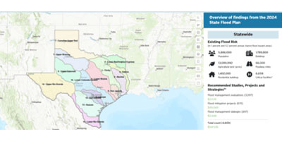
The Interactive State Flood Plan Viewer complements Texas’ 2024 State Flood Plan by providing downloadable statewide flood risk, infrastructure, and mitigation information. It helps users assess local flood risks and support planning decisions. Because conditions change, users should also consult local studies and FEMA maps. State Flood Plan data is updated every five years.
Flood Decision Support Toolbox

Interagency Flood Risk Management (InFRM) Flood Decision Support Toolbox shows real-time weather information and includes the estimated depth of water in hypothetical flooding scenarios. You can answer questions like “Will my house flood if a flood event causes the Colorado River to rise 10ft?”